Even 16,500 feet in the air, perched on the steep slope of a volcano in Ecuador, French glaciologist Bernard Francou moves gracefully. Hopping among ice blocks and jagged rock debris, he stops suddenly before a boulder with blue letters painted on its surface.
The thinker: Bernard Francou.
Photo: Bernard Pouyaud, Ecuador Instituto
Nacional de Meteorologia e Hidrologia.
“This is where the glacier stopped when I first came here seven years ago,” Francou explains, oblivious to the cold and the drizzle. He then points more than a football field’s distance uphill, where a wall of blue ice marks the present-day terminus of Ecuador’s Antizana glacier.
All over South America, glaciers are meeting the same fate as Antizana: Within the next 15 years, all of the continent’s small glaciers — about 80 percent of the total — will disappear, according to Francou. He should know: As director of research for the French government’s Institute of Research and Development, Francou has been researching tropical glaciers for 15 years, making him one of the foremost experts in the field.
“The trend is so clear that you can’t argue with the numbers,” Francou claims.
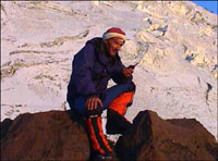
Antizana glacier in 1994 (top) and 2000
(bottom).
Photo: Bernard Francou, Eduador Instituto
Nacional de Meteorologia e Hidrologia.
And sure enough, the numbers are sobering: Between 1996 and 1998, the Antizana glacier shrunk 100 yards and lost 8 percent of its area. Smaller glaciers are melting even faster; the Chacaltaya glacier in Bolivia lost nearly half of its area and two-thirds of its volume during the mid-1990s alone.
The disappearance of these glaciers is bad news for South American cities that rely on them year-round for water and hydroelectricity. Quito, the capital city of Ecuador, gets fully half of its water from the Antizana glacier. Concerned about maintaining the supply, the municipality is jointly sponsoring Francou’s monitoring of the Antizana glacier with the Institute for Research and Development. “For me, this glacier study is about climate change,” explains Francou. “For the government of Ecuador, however, it is about economic impact.”
The government has ample reason to be concerned: The other half of Quito’s water supply comes from the paramo, a high-altitude ecosystem of thick, matted plants that will most likely disappear when the glaciers do. “We know that the glaciers cause passing moisture from the Amazon to fall as rain,” explains Edgar Ayabaca, head of Quito’s municipal water utility. “The paramo absorbs this water like a sponge and releases it slowly. What we are studying is whether the paramo will become a desert when the glaciers melt.”
Retreat!
To see first-hand what is happening to South America’s glaciers, I accompanied Francou and his Ecuadorian counterpart, Bolivar Caceres, on a monitoring trip to Antizana. Our mission was to take measurements both at the bottom of the glacier and at the mountain’s 19,000-foot summit.
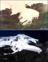
Antizana.
Photo: Bernard Francou, Eduador Instituto
Nacional de Meteorologia e Hidrologia.
Francou’s team visits their glaciers every other week, so it’s handy that Anizana is just an hour and a half drive from Quito. The last part of the journey is on a deeply rutted track that winds through acres upon acres of barren paramo, broken only by a herd of goats and the crystalline white cone of Antizana. On the other side of this massive volcano, the land drops down into the Amazon basin; water from the region drains into Brazil and beyond.
Along the way, I asked Francou, who has similar teams working in Bolivia and Peru and is hoping to start a new project in India, why he studies climate change in the tropics, when most of his colleagues focus on either the Arctic or the Antarctic.
“After the poles, the tropics are perhaps the area most heavily affected by climate change,” he explains, pointing in the direction of the nearby Pacific Ocean where the cycle of ocean warming known as El Nino is born. “As the frequency and intensity of the El Nino cycles increase, these glaciers respond immediately.”
Although Andean glaciers have been retreating since the end of the Little Ice Age (around 1870), the pace of melting skyrocketed with the warm El Nino conditions of the 1990s — which was also the hottest decade in recorded history. The Antizana glacier shrunk seven to eight times faster than normal during that 10-year span.
To Summit Up
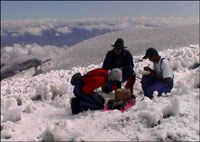
When we arrived at the end of the road, we put on climbing boots and began to ascend a series of moraines, huge rock piles that were bulldozed into shape by the glacier in centuries past. After a half-hour walk, we strapped on crampons and climbed onto the glacier, where dozens of plastic tubes jutted out at odd angles from the icy surface.
“A glacier has two parts,” explained Francou as he approached the first tube. “On the top half, snow accumulates and pushes the glacier downhill. On the bottom half, the ice melts and causes the glacier to shrink. The line between these two is the equilibrium line.”
Measuring ice thickness.
Photo: Bernard Francou, Eduador Instituto
Nacional de Meteorologia e Hidrologia.
By calculating the average of the distance the tubes protrude from the surface of the ice, scientists can determine how much snow has melted from the bottom half of the glacier. The counterpart of this measurement — which we planned to do the following day — involves digging snow pits in the upper half of the glacier to determine how much snow had accumulated in the year. The difference between how much snow has melted and how much has accumulated is called the glacier’s mass balance.
In the course of checking tubes, we also stopped at two aluminum tripod-like structures laden with instruments and looking very much like NASA space probes. “These stations tell us the glacier’s energy budget,” explained Ecuadorian scientist Luis Maisincho. “These instruments calculate how much energy enters the glacier via sun and wind and how much leaves via evaporation and sublimation.” Data is stored in a miniature hard drive, which Maisincho pulled out and replaced with a fresh unit.
Late that afternoon, we descended the glacier in a rain storm and huddled inside our Land Cruiser, where we drank hot soup before heading to bed. I found sleeping at 15,850 feet to be challenging, so I was not exactly jarred out of a deep slumber when Francou woke me at midnight. By 3 a.m., we had climbed past the tubes we’d measured the day before. We had also passed the equilibrium line — the point at which melting stops and accumulation begins, where ice turns to snow underfoot.
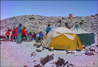
Base camp.
Photo: Robert Galliare, Eduador Instituto
Nacional de Meteorologia e Hidrologia.
There are definitely challenges to being a glaciologist, and all of them were readily apparent during our pre-dawn trek. We trudged endlessly uphill into the thinning air in pitch black, all the time working against 40 miles-per-hour wind gusts and knee-deep snow. Everyone on the expedition was roped together in case someone fell into the snow-covered crevasses that crisscrossed the slope in front of us.
Around 5 a.m. Francou stopped dead in his tracks on a steep slope and plunged his ski pole into the snow. He gathered the rope between us and shouted against the wind into my ear. “This snow is too unconsolidated and the risk of an avalanche is rising,” he said, scanning the blackness above him. “Too many people have died in conditions like this. We must turn around.”
So much for the snow pits; Francou placed a few more tubes and vowed to return the next month with Caceres to try again to reach the summit. It was now raining well above the snow line, which seemed a fitting illustration of the kind of atmospheric warming that is causing this glacier to retreat by leaps and bounds.
We were back in camp by 9 a.m., but before returning to Quito we had the final task of checking the two hydrological stations. These stations measure the amount of water melting from the glacier — the final piece of the puzzle that is the glacier’s behavior. Armed with the data from the tube measurements, the snow pits, the energy stations, and the water flow, Francou and Caceres can build a surprisingly accurate model of what the Antizana glacier has been up to in the last month –and what it will likely do in the future.
Sadly, as these models become more accurate, the grim truth they tell becomes more apparent: At the current pace of climate change, tropical glaciers are not long for this world. Talking for a moment to the human rather than the scientist, I ask Francou if he has a personal response to the apocalypse that is unfolding in the high mountains of South America.
The normally tireless man looks down for a moment, seemingly exhausted, and then says, “I have spent most of my life in the high mountains and I am also an alpinist. I regard all of this with much sadness.”