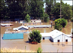
Once it was a cornfield; now it’s a Wal-Mart, a Taco Bell, a Target. Here along a stretch of Missouri’s Highway 40, in the Chesterfield Valley area just west of downtown St. Louis, what’s said to be the largest strip mall in the country sits on about 46 acres of Mississippi River bottomlands. Less than 20 years ago, the land was open space.
It’s been fifteen years since the Great Flood of 1993 put this land under 10 feet of water. Since then, thousands of acres of floodplain in the St. Louis area have been built up with strip malls, office and industrial parks, and 28,000 new homes. And all this infrastructure depends on miles and miles of levees to hold back the Mississippi and Missouri rivers the next time they try to retake the land.
If you ignore the historical tendency of the Mississippi and Missouri to periodically drown it, this vast, flat landscape does present an appealing canvas for building. “When you have such an expansive floodplain, people don’t have a problem with building on the fringes,” says Dan Burkemper, director of the Great Rivers Habitat Alliance. “And then the fringe moves closer to the river every day.”
The Flood of 1993 was one of the most destructive in the recorded history of the Mississippi Basin: nearly 50 people were killed, over 70,000 evacuated, and 50,000 homes damaged on over 17 million acres (close to 27,000 square miles) across nine states. Over 16,000 square miles of working cropland was flooded, at a loss of more than $5 billion. All told, the flood caused around $16 billion in damage.
In the first blush of post-flood shock, some local and federal officials decided that trying to hold back the Mississippi River was likely to be a costly and never-ending enterprise. Instead of depending on levees and other structures for protection, some thought, it was time to move people’s homes and workplaces off the floodplain and cede ground to the river.
“We must and can work to design and build our communities better and, to the extent possible, out of harm’s way,” then-director of the Federal Emergency Management Agency James Lee Witt told Congress later that year. “Mitigation must become a priority throughout all levels of our government. We must be proactive on mitigation and not reactive.”
Flood me once, shame on you … flood me
twice, shame on me.
Photo: mo.water.usgs.gov
And FEMA acted on this notion: In the nine states flooded in 1993, the agency ultimately moved more than 300 homes, and bought and razed nearly 12,000, at a cost of over $150 million; the lands were turned to flood-friendlier uses like parks and wildlife habitat. The village of Valmeyer, Ill., just downriver of St. Louis, became the buyout poster child: devastated when floodwaters overtopped its levee (an event that likely helped save St. Louis itself from a major flood), the entire town packed it in, selling out its bottomland location for a new site two miles away — and 400 feet above the Mississippi floodplain.
It may have been the greatest exodus of Americans from floodplain homes and businesses in the nation’s history.
But official resolve to depopulate the floodplain has given way to development fever in Missouri: over $2.2 billion worth so far on land that was underwater in 1993. And unlike some of the other states deluged in the Flood of 1993, such as Wisconsin, Iowa, and Illinois, Missouri has been much slower to enact stronger regulations for floodplain development — perhaps because the state has hundreds of miles of floodplain fronting the Mississippi and Missouri rivers (read: lots of tax income lost and jobs unrealized if new businesses and homes don’t get built).
In the St. Louis metro area, there’s been more built upon the floodplain since 1993 than in its entire prior history, says Tim Kusky, a professor of natural sciences at St. Louis University. This development brings new pressures that haven’t been assessed for how they might intensify flooding elsewhere, or cumulatively damage floodplain ecosystems.
“Since 1993, projects now complete, underway, and in planning have put or will put [28.1 square miles] of the Mississippi and Missouri floodplains near St. Louis behind new levees, enlarged levees, or floodplain land raised above the 100-year to 500-year protection level,” wrote Southern Illinois University at Carbondale geologist Nicholas Pinter in the journal Science in 2005. Those projects included over $190 million spent by the Army Corps of Engineers to work on nine levees in its St. Louis District.
The corps argues that flood-control structures prevented $19 billion of damage in 1993 across the nine states affected. But is the confidence that these protections inspire part of the problem? “Most infrastructure on the floodplain would not be there were it not for the historic reliance on levees,” Pinter noted in Science.
“[The Army Corps] thinks that the levees are going to protect the people behind them, and the businesses behind them,” says Kusky, “because there are calculations based on the assumed risk of floods on the hundred-year floodplain and the five-hundred-year floodplain.” But, Kusky says, “there’s a problem with that calculation.” The problem — shocker! — is global warming.
“We’ve calculated things like the hundred-year flood, five-hundred-year flood, based on current amounts of water in the river, not with any global change factored into that,” Kusky says. But according to well-accepted models of how human-caused climate disruption will affect the St. Louis area, average yearly rainfall will rise by 21 percent within the next 30 years — increasing the amount of water in the Mississippi River by just over 50 percent.
Even with current amounts of water in the river, there have been around seven 100-year floods along the Mississippi over the past century, he says. So “how are we going to handle an extra 50 percent of water flowing in the rivers every year, and what effect is that going to have on the predicted flood stages, and the frequency at which we get the hundred-year and five-hundred-year flood, and all the other floods in between?”
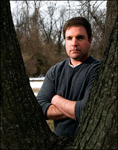
Dan Burkemper.
Photo: Mark Hirsch
With all those houses and malls and more going up on the floodplain, his questions are more than academic.
Back to Dan Burkemper and the Great Rivers Habitat Alliance, which has brought together Missouri conservationists, farmers, and hunters who want to keep the floodplain near the confluence of the Mississippi and Missouri rivers largely undeveloped. GRHA advocates traditional uses like farming, hunting, wildlife conservation, and boating on the floodplain. In 2007, in a joint effort with the National Rifle Association, GRHA scored a victory with the enactment of the state “Hunting Heritage Protection Areas Act,” which will prohibit certain kinds of development on the 100-year floodplain in Missouri.
But the group’s work is far from done. It is currently involved in a lawsuit against the city of St. Peters over a development called Premier 370, begun before the Hunting Heritage law was passed, which aims to create a huge industrial park on hundreds of acres of former farmland on the 100-year floodplain. St. Peters financed the construction of a levee to protect the development.
For its part, the developer of Premier 370 says that of the total acreage devoted to the project, roughly half — the half that’s on the river side of the levee — will be devoted to wetlands, a lake with camping and fishing, and other recreational uses. And St. Peters will still get the economic engine it was hoping for, says Mike Hejna, president of Gundaker Commercial Group: “When this complex is completely built out, it could be up to 10,000 employment, and close to 10 million square feet of industrial space.”
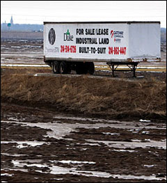
If you like this, we’ve got some swampland
in Florida we’d love to sell you.
Photo: Mark Hirsch
Burkemper rails against this sort of rationale. “You had farmers, with their family farms, that have been operating for generations. You’ve got hunters that value the land and put a lot of money toward conservation,” he says. “Those two groups have lived happily for a long time. It’s only recently, when you have a developer come along and offer an exorbitant amount of money for the land, that that’s disrupted.”
Burkemper would like to see the Army Corps take a stronger position on advocating sustainable development on the floodplain. “When you have the Corps of Engineers that says … it’s fine if you build a levee there, we’ve got the river under control, nothing to worry about, [then] there’s no reason why [developers] wouldn’t, that’s the bottom line.”
But ask the Army Corps, and it will tell you that kind of advocacy is not the job that Congress — and by extension the taxpayer — has hired it to do. “When we’re looking at floodplain development, or wetland impacts, we have to really look at things as they are, not how we’d like them to be,” says Alan Dooley, chief of Public Affairs for the St. Louis district of the Army Corps. The agency is limited by law to responding to the wishes of Congress and regional officials in creating flood protections like levees, he says, and to reviewing floodplain development proposals for compliance with Section 404 of the Clean Water Act, which regulates the discharge of dredged or other fill materials into U.S. waters — including many wetlands.
“We’re not looking for loopholes to get rid of wetlands; we’re looking for ways to save wetlands,” says Dooley. “But if the American public comes in with a request to do something on their own property, and they follow the permit process and fulfill it, we have to give the permit.”
Asked how receptive the Army Corps has been to his research on the river’s present and likely future conditions, Tim Kusky answers circumspectly. “They’re doing their job, and so far their job is to calculate the effects of any levee they’ve built, at that particular levee, on the river dynamics,” he says. “They don’t need to calculate … the cumulative effect of all the levees.”
It’s become generally understood that ever higher, stronger levees lead to higher water levels during floods, with faster moving water building up tremendous force. Even if a levee holds in one location, the water it sends downstream is more powerful and potentially dangerous than before. Kusky likens the destructive power of a levee breach under these conditions to the force generated by Niagara Falls.

Kathy Andria.
Photo: Mark Hirsch
To Kathy Andria, an eco-activist in southwestern Illinois, the levees that have been newly built or improved to protect development on the Missouri side of the greater St. Louis metro area are intensifying the dangers along her stretch of the Mississippi — where FEMA recently declared that the five 70-year-old levees protecting East St. Louis, Ill., don’t meet current standards for flood protection. While these levees held in 1993, there were extensive “sand boils” — eruptions of water and dirt on the land side of the levees — that had to be sandbagged to withstand the Great Flood.
“The Army Corps of Engineers has identified some design deficiencies that allow under-seepage that can lead to levee failure,” says Terry Fell, chief of Floodplain Management and Insurance for FEMA’s Region Five, based in Chicago.
Ultimately, FEMA intends to remove these levees from its flood vulnerability maps, essentially denoting the area as an unprotected floodplain –which could have big economic consequences for the area. “I don’t believe that the communities in this area had a general awareness of flood risk, or are in general pleased to find out about it,” says Fell. “But they’re now eager to find out what steps they can take to get levees repaired.”
Andria — who is president of the American Bottom Conservancy and conservation chair of the local Sierra Club group — charges that so far, the Army Corps is taking a less-than-aggressive approach to repairing the levees. “I’ve been to several meetings where the corps said that they were going to do what they could do,” she says, “but that it was up to the local people to get the money to match it [federal funding], and to get the money appropriated from Congress.” According to both Fell of FEMA and Dooley of the Army Corps, local officials are lobbying the area’s federal legislators to get that funding.
Meanwhile, growth continues. Industrial facilities dotting the Metro East area (as the Illinois counties due east of St. Louis are known) include the ConocoPhillips Wood River Refinery about 15 miles northeast of St. Louis, which puts out around 322,000 barrels a day of crude oil and wants to expand capacity. And on the western edge of Horseshoe Lake, an old meander of the Mississippi River (which it tried to reclaim in the Great Flood of 1993), U.S. Steel’s Granite City Works has an annual steelmaking capacity of 2.6 million tons and a new coke plant on the way. There’s a new soccer stadium proposed for an area on the floodplain just north of East St. Louis, where acres of warehouses have also popped up in recent years — increasing runoff problems, says Andria.
While the area’s congressional representatives and local officials want to get the levees upgraded, “I just think that some of it might be for the wrong reasons,” Andria says. “Rather than to protect people, it’s to protect future development [and] worrying that Missouri is going to get one up on us.”
And because the floodplain north-northwest of St. Louis proper — which flooded in 1993, joining the overtopped Valmeyer levee in likely preserving St. Louis from a dunking — is now largely bounded by newer, stronger levees, there’s going to be even more fast-moving river water pressing against the East St. Louis levees in the next big flood. The levee built by the developers to protect that enormous strip mall in the Chesterfield Valley is designed to withstand a one-in-500 flood. And the one-in-500 levee financed by the city of St. Peters to protect Premier 370 was recently qualified for acceptance into the federal levee program — which means that the Army Corps will pay for nearly all future repair costs due to flood damage.
Fell doesn’t agree that there’s a one-to-one correlation here: “The Mississippi River watershed is so huge that there is less likelihood of anything on the Missouri side having a real significant impact on the Illinois side.” But geologist Pinter disagrees. “Our research has shown that every single percent of floodplain land that is leveed shows a measurable increase in flood levels on the floodplain on the opposite bank upstream and downstream,” he says. “Individual levee projects are permitted on the basis of local hydraulic models, which are running on 1940s technology. You can make those models give you any answer you want. The permitting process is based on an analytical technique that is insensitive to the truth.”
Inadequate levees, overdevelopment, oil refineries, and a history of catastrophic floods. Does this situation sound familiar?
“We’re very much in a position to be another New Orleans” in East St. Louis, says Kathy Andria. “We’re in a really precarious spot here.”
