Here’s my second post from the tar sands. The first post, on the town of Fort McMurray, is here.
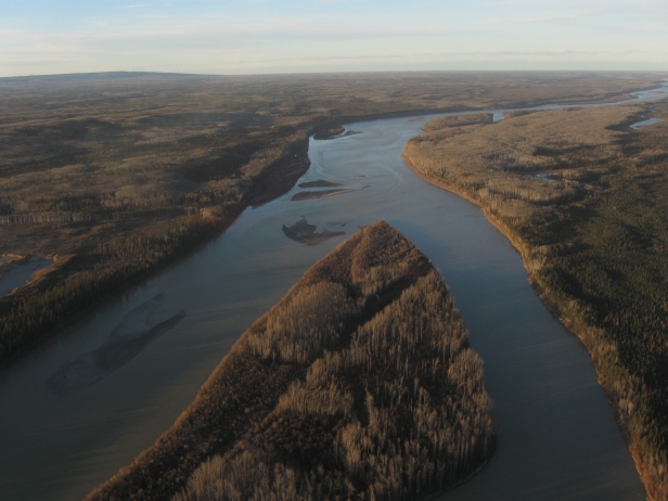 The Athabasca River flows north through the estimated second largest known oil reserve in the world.Photo: Jonathan HiskesI’d expected to discover that flying in a helicopter over the tar sands of Alberta, Canada, might help me understand the scale of the development here. Instead of just reading about it, I would be seeing the place where more earth is being scraped, dug, blasted, and plowed than anywhere else on Earth.
But it didn’t work out that way. Up close, the tar sands are too big to comprehend.
I’m here with Todd Paglia and Aaron Sanger of ForestEthics, who have kindly paid for me to join them on a trip with several of their funders. The flight almost didn’t happen. Nine helicopter companies refused to do business with the group, which opposes the mining that is the region’s economic lifeblood. The tenth company was either ballsier or clueless that the oil companies had warned pilots not to cooperate with tar-sands critics.
[Update: ForestEthics Deputy Director Kristi Chester Vance wrote to give the company more credit: “The one outfit that did agree to get us in the air seemed to be acting more out of a belief that we deserved the chance to see things, rather than a clueless-ness about the industry’s request to shut us down.”]
We ascended from the burgeoning workers’ town of Fort McMurray an hour before sunset and rose above the vast boreal forest that runs to the horizon in every direction. Truth be told, it’s not the most immediately lovable country at first sight; it’s flat, boggy, somewhat featureless, famous for its mosquitoes, and mostly gray at the onset of winter. Yet this is habitat for moose, wolves, and gazillions of other creatures. Lovable or not, it’s a forest — a complete and vital ecosystem.
Except where it’s not — where black-and-tan strip mines the size of airports appear on the landscape like sores. As we approach them, I realize they’re much bigger than airports. Several of them, in fact, have 5,000-foot airstrips maintained by the energy companies to ship workers in and out. The cleared areas dwarf the airstrips.
 It’s tough to see here, but a steady stream of dump trucks carries loads from an orange bulldozer to an upgrader. The work continues 24 hours a day.Photo: Jonathan HiskesIt’s mostly a tan, sandy surface marked with pits, roads, and dark streaks of bitumen — a heavy black oil. The sites are busy: trucks creep along the roads, picking up loads from bulldozers the size of apartment buildings. In fact, when I look at the bulldozers from above and remember that I’ve read they’re 40 feet high, I realize I’m still misjudging the size of the excavation. It’s bigger still than I had understood a moment ago.
We fly over several such sites. It’s difficult to judge the depth of the pit mines — everything’s flattened from above. Many are 300 feet deep, the pilot says. The land has been leased out parcel by parcel to energy companies, and it’s hard to keep track of whose land we’re crossing. Each site has large “ponds” of mine tailings, the toxic, watery sludge left over from washing the oil free of sand and impurities. (Even after washing, tar-sands oil contains more toxics and carbon than conventionally drilled oil.) Many of the ponds are disturbingly close to the Athabasca River, which runs north toward the Arctic Ocean.
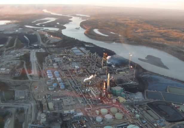
 The Suncor upgrader processes bitumen. Note the toxic waste ponds beside the river in the lower right.Photo: Jonathan HiskesAt the river’s edge, we turn toward the Syncrude and Suncor sites, with more tailing ponds and an oil sands upgrader, a network of pipelines and smokestacks. The flares reaching toward us and the smell of asphalt are reminders that this isn’t Google Maps we’re hovering over.
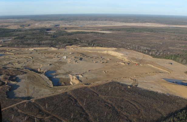
To the west of the river we leave the pit mines and approach sites using the newer “in situ” extraction method. Instead of clearing the forest and scraping away the land layer by layer, in situ drilling involves piping steam underground to melt bitumen where it lies, so that the oil can be pumped upward. It’s even more resource-intensive, because of all the water and natural gas used to create the steam. Although the forest is not clear cut, it’s altered by dynamite charges used to find the deposits and by the pipelines and roads that slice it into small sections. Sanger said he prefers the “moonscapes” of the open-pit mining to the parceled and divided in situ sites, because in situ drilling allows excavators to reach much, much larger areas. The area estimated to hold recoverable oil is the size of North Carolina, stretching east into Saskatchewan and west toward the Rockies.
We head back to the airport just as the sun disappears into the forest. I should be transfixed and horrified by the landscape, but it mostly feels removed, like watching Tolkien’s Mordor from the comfort of a sofa. I realize that I was more unsettled the previous night, when I talked to the heavy-equipment driver who sat next to me on the flight in from Edmonton. His family was back in Nova Scotia, he told me. “We make up 90 percent of the workforce here,” he said, meaning workers from Canada’s Maritime provinces*. He was exaggerating, but not by much. He didn’t say how long his time home had been, but he looked like it hadn’t been long enough. He didn’t want to be en route to the tar fields on the eve of Canadian Thanksgiving. That much was clear in his sunken eyes. I could make sense of that, unlike this view from the sky. My mind doesn’t know what to do with this.
—–
For better pictures than mine, check out Peter Essick’s tar sands photography for National Geographic.
The post originally called the Maritime provinces “impoverished.” As a reader pointed out, that’s misleading: The eastern provinces have comparable poverty and unemployment rates to the rest of Canada, although median income rates are lower.