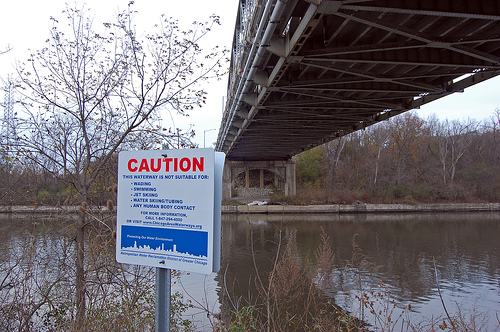
 A sign near the Cal Sag channel, part of the Calumet River System, warns against “any human body contact.”Photo courtesy Tom Gill via FlickrThe Grand Calumet River is about 13 miles long and flows through one of the most industrialized areas in the United States. At one time, the river’s branches and tributaries flowed throughout northwest Indiana and supported globally unique fish and wildlife. Today, thanks to being moved and manipulated by humans over the years, the Calumet river system is one of the smallest watersheds in the region, and there are stretches of river that support nothing but sludge worms.
How did this happen? Two words: people and industry.
Over the last 100 years, the industrialization of northwest Indiana has created the landscape -– and the river — we see today. Unmanaged pollution from industrial activities and human development has severely degraded the ecological integrity of the watershed.
The sources of pollution include urban runoff, landfills, dumpsites, industrial manufacturing and processing, and sewage treatment plants. The river has high levels of bacteria, nutrients, cyanides, lead, arsenic, cadmium, PCBs, phenols, oil, grease, chlorides, and heavy metals, plus many other contaminants that taint the water and the sediments.
And the Grand Calumet doesn’t keep its problems to itself. The river discharges 1 billion gallons of water a day into Lake Michigan, whose shores are home to 12 million people. For this reason, the U.S. Environmental Protection Agency considers the Grand Calumet as one of 40 “areas of concern” in the Great Lakes and initiated a cleanup plan for the river in the mid 1980s. In 2004, a legal settlement identified nine companies responsible for contaminating the river and tallied $56 million in cleanup costs.
Just cleaning up the discharge from industry and the surrounding communities will not improve the water quality of the river. In order to really bring this aquatic system back to life and make it appealing again to the surrounding communities, the contaminated sediments need to be removed and, when possible, replaced with clean sediments.
From biodiversity to dumpsite
The river basin is located in an area of great ecological diversity. It occupies the confluence of three biomes, or ecosystems, that came together during the last glacial period. They are the eastern deciduous forest, the boreal forest, and the tall grasslands. There are also plentiful streams, wetlands, and lakes.
During the retreat of the glaciers approximately 18,000 years ago, the drainage patterns of what is known as Lake Michigan’s lake plain changed, resulting in the formation of the Grand Calumet River. A few cooler-climate plants and animals adapted to the warmer conditions but most moved north with the receding glaciers. An extensive coastal marsh system developed between the dunes, creating habitat for a wide variety of animals, ranging from wading shorebirds to reptiles, mammals, and plants.
The earliest humans in the area were the Potawatomi, and the river takes its name from an elaborate Native American peace pipe called the calumet. When European settlers moved into the area in the 1830s, they cleared the forests where they could and attempted to work the land. The land, however, was usually too wet for cultivation. The two rivers, the Grand Calumet and the Little Calumet, lazily flowed through the area. Transportation was difficult even with the two rivers because of their shallow depth, their low flow, and the surrounding wetlands.
But with Chicago directly to the west, development was bound to happen! The area became an important transportation corridor as a mail route was established in 1831. By 1833 a stage was operating between Chicago and Niles, Mich. The area became an industrial and economic hub, and that growth eventually dominated the landscape.
The first industries to arrive were sawmills and grist mills. For obvious reasons sawmills were located in the heavily wooded areas and for convenience the grist mills tended to be located nearby. The Little Calumet River was the river of choice for transporting logs because it flowed faster than the Grand Calumet River. Other industries soon followed, including sand mining in the dunes along the shores of Lake Michigan. As logging continued and sand mining progressed, erosion damaged the river.
Going against the flow
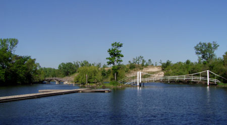 The Marquette Park lagoon is now home to the headwaters of the Grand Calumet River. The river used to empty in to Lake Michigan in this spot, before human intervention reversed its course.Photo courtesy of Ground Work GaryThe Grand Calumet River was eventually channeled to create a navigable waterway. In 1862, a feeder canal was built that enabled the Grand Calumet River to flow into the Illinois and Michigan Canal to the west. This reversed the flow of the river so that it eventually emptied into Lake Michigan via the canal. In the 1870s the federal government constructed the Calumet Harbor to make the river navigable for shipping. By the early 1900s, the Indiana Harbor Ship Canal was completed and connected the Grand Calumet River to Lake George, Wolf Lake, and Lake Michigan.
By the 1850s, several rail lines crossed the Calumet basin. So now, with various modes of transportation available for the movement of people and the expansion of commerce, the Grand Calumet River in 1885 was feeling the effects of increased sedimentation and contaminants. Industrial effluent was being discharged directly into the river from foundries, meat packing plants, sewage treatment plants, and eventually steel mills. The first major industry to move into the region was the George H. Hammond Packing Company followed by the arrival of the Standard Oil Company in 1889. Inland Steel moved to the region in 1902 and the city of Gary was born with the establishment of U.S. Steel in 1905. Midwest Steel came to the region in 1929 with other industries quick to follow. At this time, dredging the sediments became a futile task because the contaminants were entering the river system faster than they could be removed.
The Federal Water Pollution Control Act of 1972 requires the Indiana Stream Pollution Control Board to issue permits to stream dischargers through the National Pollution Discharge Elimination System (NPDES). Because of this requirement, the steel mills removed solid and acid waste from their effluent. The NPDES is recognized as playing a major role toward helping clean up the water quality of the Grand Calumet River. With cleaner water coming in to the river, eventually it became reasonable to think about getting rid of the toxic legacy at the river’s bottom.
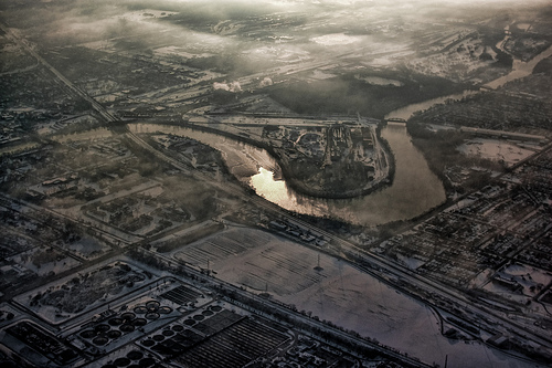
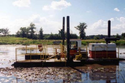 A hydraulic dredge at work on the Calumet River, as part of U.S. Steel’s dredging project. Photo courtesy of U.S. SteelFrom 2002 to 2008, U.S. Steel dredged a portion of the east branch of the river. The sediment remediation project is recognized as the largest of its kind to be undertaken in the United States. U.S. Steel removed approximately 750,000 cubic yards of sediment from the 5-mile stretch. This project also involved the construction and operation of an on-site disposal area, called a Corrective Action Management Unit or CAMU, which is visible from the Indiana Toll Road and contains the dredged sediment. A cap was placed over the river bed and clean sediment placed over the cap. The next section of the river to be dredged is a one-mile segment of the west branch in Hammond, Ind. Dredging is expected to begin this year.
Locals agree that dredging the river to clean out the toxic sediment is key to restoring the health of the river. But more needs to be done to help nature recover from more than a century of abuse. Even if the contaminated sediments are removed and the river bottom is capped with clean sediment, there are still other contaminants continually infiltrating the river, such leaking underground petroleum tanks, combined sewer overflows, and stormwater runoff from waste disposal and storage sites.
Besides the removal of sediments, various other projects could help reduce pollution sources to the river. These include plants and green space that can absorb street runoff. Separate sewers may be necessary to keep stormwater from causing sewage overflows into the river. But no matter what happens, all of the restoration efforts combined will only lead to an improved environment for both the citizens of the region and the plants and animals that currently make this area their home and future animals and plants that will return to the region.